2009年5月12日星期二

Regional Geography


Review
1. Choose a region of Canada. (We have learned)
The Great Lakes.

2. Find a picture you like of this region.


3. Tell me about this region's climate, vegetation, topography. Use 5-8 sentences.
This region's climate is humid because of the presence of the Great Lakes.The Great Lakes tend to cool the temperature during the summer. But warmer in winter.There are many kind of trees in this region.Like spruce tree,oka tree,pine tree,cedar tree,maple tree...


4. Find a picture to show this region's climate. Be creative.

This is the change of The Great Lakes.


5. Find a picture to show this region's vegetation. Be creative.


6. Find a picture to show this region's topography. Be creative.(If you need help, find the information in your textbook)


The review sheet is going to be given to you by the end of this class!!
Test on Monday.~

2009年5月10日星期日

Arctic.

1. Find a map that shows you the Arctic Region in Canada. Explain what you see in 3-5 sentences.

I can see the place that in the region.They are many region:Pelly bay.Cambridge bay.And some others.


2. Find a picture of the Arctic region you like or don't like. Explain what you see in 5 sentences!

I like this picture.Those are polar bear.I always want to see the lovely huge polar bear.I can see the snow on the ice.And the polar bears sit there cutely.


3. The Arctic region's climate has long, cold winters and short, cool summers! There is very little precipitation in this region. What would your life be like if you lived here? Explain in 5-8 sentences.

If I live there,I think I would not happy.Because the winter is long and cold.It would frozen my ears.But there is still a short summer.I could swim there.I would like to take an umbrella,to avoid the rain.I would take some food and snacks,to make my life there more interesting.May be in winter the violent wind would blow my house up.So I would build my house hard.


4. The Arctic region's vegetation include small shrubs, mosses and lichens.

a. Translate shrub into Chinese.
灌木。
b.Translate mosses into Chinese.
苔藓。
c.Translate lichens into Chinese.
地衣。

5. The Purple Saxifrage is a low-lying plant that grows in the Arctic region. Can you find a picture of this plant?


6. Trees cannot grown on tundra.

a. What is tundra? Translate into Chinese.
苔原。
b. Explain what is it in English in 2-3 sentences.
A vast treeless zone lying between the ice cap and the timberline of North America and Eurasia and having a permanently frozen subsoil.


7. Find a picture you like of the Arctic tundra. Post it! Explain what you like about it in 3-5 sentences.
I like this picture.Because the tundra looks so cool and large.It seems I can ly there for a whole day!!Or I could drive a car.I think no body could stop me there.

2009年5月7日星期四

Western Cordillera Part 2

Let's continue with the Western Cordillera Region!


1. Find a picture of the Douglas Fir. Post it. Have you seen this tree?

Yes,I have ever seen it.


2. How can you remember what this tree looks like and it's name?
There is a tree outside our class.Every day I go there so I can see the tree.
3. Find a picture of Western Hemlock. Have you seen this tree before?

Yes.I've seen it before.


4. When you look at a Western Hemlook, what is special about this tree. Tell me 3 things about this tree?
1.Straight
2.High.
3.Always be green.

5. There are many mountains in this region. What do you think happens to the vegetation when we get higher up to the mountain? Can you guess?
I think When I get on the top of the mountain,I would feel nervous.May be I would suffercate.Because there is less air on the top of the mountain than land.


6. In the southern part of the Western Cordillera region, there is less rain. If there is less rain, do you think the great evergreen trees will grow?
Yes.Because the evergreen trees are adamant.At least there is much sunshine.So if there is no water,the trees would still grow well.


7. The largest trees in the world exist in this region. They can be found in the United States because this region is very long and goes all the way down into Canada's neighbor!!! These trees are called "Giant Sequoias".


a. Find a picture of a Giant Sequoia you like. Explain why you like or don't like it in 3-5 sentences.

I see the HUGE Giant Sequoia tree.The human being just like a ant under the tree.I like this picture.It isn't be puff.It is the real tree.

8. What did you learn today? Explain in 5-8 sentences. Be serious!!!!
The most impressed thing is the HUGE tree!!!It is so huge.I know 3 kinds of trees today. I know their names.I know 3 things about the WESTERN HEMLOCK.I thought I can see them in Canada.But also ion China.Except the last huge Giant Sequoia tree.

2009年5月5日星期二

The Western Cordillera

THE WESTERN CORDILLERA
This is a mountain in The Western Cordillera Region!


1. Find a photograph of the Western Cordillera Region. Post it.


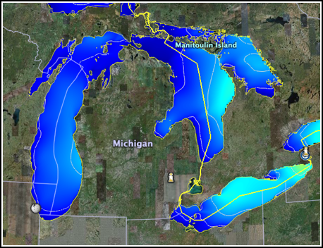
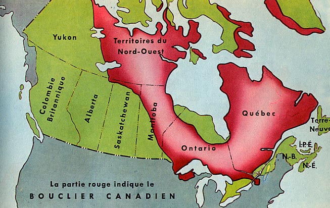
2. Find a map of The Western Cordillera region.Explain what you see in the map in 3-5 sentences.This region has range after range of mountains, separated by plateaus and valleys. The Rocky Mountains are the most easterly range of mountains in this region.
There are many region I can see.There is:Interior Plains,Great Lakes-St.Lawrence Lowlands,Atlantic&Gulf Region,Western Cordillera,Canadian Shield,Sub-Arctic,Plateau.


3. Find picture you like of the Rocky Mountains.Explain why you like it in 5-8 sentences.

I love this picture.Because the sky looks sooooo clean!!The mountain is very high,the white part on the top of the mountain,may be they are snow.It was so splendid.There is a wisp of gray cloud,it looks cool!!So the mountain must be very high.The picture everywhere is green,looks comfortable.


4. The Rocky Mountains are fold mountains.a. How are fold mountains made? Use your OWN words to explain this process.Go to this website to find the answer: http://library.thinkquest.org/17701/high/geofeatures/fefoldmt.html.What are some other examples of fold mountains?
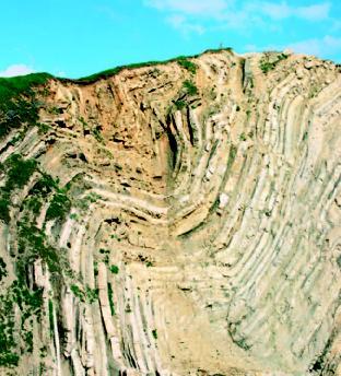
I think fold mountains' form is cause of the earthquake,or something that in early years crush on the mountain.The earthquake occur so the mountains change into the crossbedding.The soil extrusion the sediment layers.So it forms a fold moutain.The layer of soil between the topsoil and bedrock.


5. Find a photograph of another fold mountain in the world. Post it.Explain what you see in 3-5 sentences.
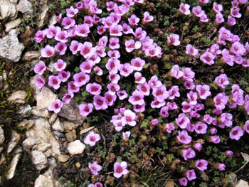
I can just see a large rock.May be it is a part of the fold mountain.There is moss on the rock.The sky is so blue that like a sea and near violent.

6. There are a lot of mountains in this region, would you want to live here?Tell me three reasons why or why not.
I don't want to live there.
#Because the moutains are so large that make me afraid.
#There is no semaphore.
#I will miss my mum and dad.

7. What did you learn today? Explain in 5-8 sentences.
I learned about the moutains.I know what is the FOLD MOUNTAINS is.I know how fold moutains' form.I know the regions there.And I knowthe region's name.

2009年5月3日星期日

The Canadian Shield

The Canadian Shield
1. Find a map of this region. Which provinces are in this region
There are many province in this region:Quebec,Territories Nord-Quset.Almost the part of Ontario and almost part of Manitoba.


2. Translate erosion. What is erosion? Explain in your own words.
腐蚀。The wearing away of rocks and other deposits on the earth's surface by the action of water, ice, wind.Or the act or process of eroding or the state of being eroded.


3. Why do you think the climate of this region will vary? Explain in 3-5 sentences. Look at the map of this region and think about it.
I think it is because the region is so big thst the climate is vary.The north region is colder,so the soth region is warmer.I think this is the reason.


4. The vegetation of this region is mostly boreal forest. What is special about a boreal forest? Explainin 3-5 sentences.
I think the special of the boreal forest,is the shape of the trees.The boeal forest,every tree is very straight and high.


5. Find a picture of the Canadian Shield. Explain why you like this picture in 3-5 sentences.

I like this picture because I can see the straight and high trees.The big and grow the grass on the edge.I can see the moutain clearly.The blue sky and the white cloud make me comfortable.


6.There is a lot of mining in this area. The Canadian shield is sometimes called a "mineral storehouse" because it has a lot of valuable minerals like lead, copper, gold, zinc and nickel.

a. Find a picture of lead. Post it.


b. Find a picture of copper. Post it.


c. Find a picture of gold. Post it.


d. Find a picture of zinc. Post it.


e. Find a pciture of nickel. Post it


7. If you were the owner of a mining company, why would you want to come to this area? Tell me at least 2 reasons.
!Because there are many treasure~
!Because treasure can make you more money.


2009年4月28日星期二

Regional Geography

1. Are there geographical regions in China or Korea? Explain in 3-5 sentences.
They are in China.Every where n China is a geographical regions.Like:Beijing,Hebei,Shanxi,Hainan.Sichuan..


2. Post 3 pictures of China's regional geography. It can be photographs. Explain each picture in 5-8 sentences.

Ts is Yunnan,this is the place that I want to go,always.I heard that the terraced field there is very beautiful.It has many colors.The color of the field,why it is coloful? I think it might be the sun or the forest.When the sun begin decline,the vivid sun color shot to the field,and the field would turn into red,orange.But bthe trees are green,so there are more green.I think.


This is China's capital city.Named:beijing.This is The Great Wall.It has been a symbol of China.Look at the top of the great wall,there is a doll stand on there.It name is Huanhuan,It is Olympic's symbol.And there are lots of people,they must want to go to top of the Great wall,to see Huanhuan,I bet.

This is Hebei,my hometown.This is a kind of wall painting.It might be the anient people's work.Beautiful and full of culture.The men in the pictrue,They must be the ministers.They all listen to the great emperor


3. What have you learned about regions so far? Explain in 5-8 sentences.
I learned every region's cultrue and the symbol of the region.I know the three places,more clearly.They are:Yunnan,Hebei and Beijing.And I know what the meaning Regional Geography

2009年4月27日星期一

Climate Continued!

After learning about the topography of this region, we are going to look at the climate and vegetation of this region.


1a. Translate ocean into Chinese.
海洋。

1b. Which Canadian province is closest to the Pacific Ocean?
British Coulumbia is closet to the Pacific Ocean.

1c. Which Canadian provinces is closest to the Atlantic Ocean?
Newfoundland and Labrador is the province which closet to the Atlantic Ocean.

2. Find a picture of the Pacific Ocean you like. Explain why you like it in 3-5 sentences.


I like this pictrue because the view is very beautiful and it looks comfortable.I can see the white sand,it must be very soft and I_ think it is a good thing to play on the beach.The sea is crystal blue,so I would like to go swimming.


3. Find a picture of the Atlantic Ocean you like. Explain why you like it.in 3-5 sentences.

I like this pictrue.Because I like the large waves.I would like to play in the large waves.I wouldn't afraid of it~

4. Why would the Interior Plains region's climate be affected by the ocean. What does the ocean do for the climate? Explain in 5-8 sentences. Look at your past lesson.
It is because of the current. The two lines of current,they blow the winds and the climate of there would be changing. But there is no any ocean there.So the rei=gion when it dry it'll be very dry.When it wet,It'll be very wet.

5. What continent is the Interior Plains region on? Explain in 3-5 sentences.
I think it is on North America.Because Canada is in North America.So the Interior Plains region is on North America.

6. Where is the Interior Plains region on this continent? What provinces are in this region?
They are in the more west.Monatana,North Dakota,South Dakota,Colorado.Oklahoma,Kansas,wyoming,Nebras.

7. What did you learn today?
I leaned about Interior Plainsregion's climate.I know the climate there i svery strange.And I know the oceans that closet the region.